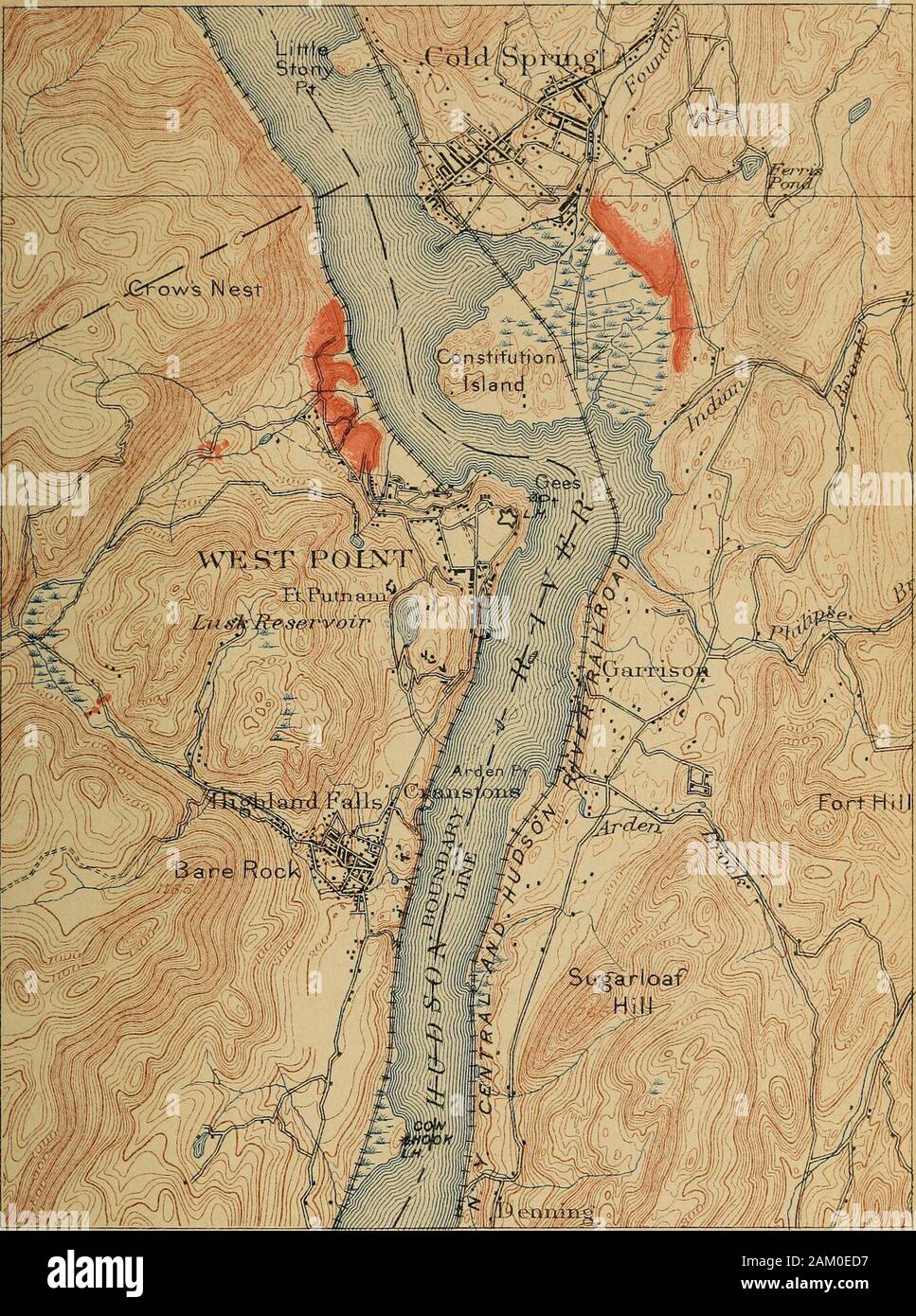
Bulletin - New York State Museum. tward bis zu einer Kreuzung mit der Highland Falls Road, dann 1,6 km südöstlich von der Kreuzung, die Straße fährt adistinct Moräne bildet eine auf der nördlichen Seite der thevalley Sporn. Die dejiosit ist konvex Downstream und ist wahrscheinlich ein dueto lobelet des Ice drückte durch dieses Tal zu diesem pointprior in den Halt auf dem 400 Fuß Kontur über West Point. Diese Angaben sind als zeigen den Beweis der Succes- sive Stufen in das Abschmelzen des Eises im Tal erwähnt. Soweit die Terrassen an der West Point Stufe betrifft, deren Annäherung in der Ebene
1364 x 1832 px | 23,1 x 31 cm | 9,1 x 12,2 inches | 150dpi
Weitere Informationen:
Dieses Bild ist ein gemeinfreies Bild. Dies bedeutet, dass entweder das Urheberrecht dafür abgelaufen ist oder der Inhaber des Bildes auf sein Urheberrecht verzichtet hat. Alamy berechnet Ihnen eine Gebühr für den Zugriff auf die hochauflösende Kopie des Bildes.
Dieses Bild kann kleinere Mängel aufweisen, da es sich um ein historisches Bild oder ein Reportagebild handel
Bulletin - New York State Museum . tward to a junction with the Highland Falls road, then mile southeast from the junction, this road traverses adistinct moraine forming a spur on the northern side of thevalley. The dejiosit is convex downstream and is probably dueto a lobelet of the ice pushed through this valley to this pointprior to the halt at the 400 foot contour above West Point.These details are mentioned as showing the evidence of succes-sive stages in the melting of the ice in the valley. So far as the terraces at the West Point stage are concerned, their close approximation in level with the hight of the old rockterrace, the filling of spaces in the river bend upstream from theproject i(.M of I lie old rock Icrrncc, and IIk^ linn veneer of thewash of lliis si ago over the old rock terraces on both sides ofthe river suggesl Ilia! the rock terrace controlled the hijrht of •OltfMl by I)r F. J. II. Merrill, in Am. Jour. Sci. 1896. 41:461. PART OF THE WEST POINT QUADRANGLE N Y STATE MUSEUM B U LLETl N 84 PLATE 3. ///./ ^/ /.^ A M W DEPOSITS AT WEST POINT AND COLD SPRING. Scale ContoTo? iiiteival 20 feet. DatiifTv is irve^vn, sea, ler^el. 2 Mies Glacialterraces. Frontalmoraine. ANCIENT WATER LEVELS OP CHAMPLAIN-HUDSON VALLEYS 113 the terrace building by gravel-bearing streams. This evidenceis stronger when it is noted that both rock terraces and glacialterraces are at this point in the river somewhat higher than atPeekskill. The elevation of the glacial terraces at Peekskill isfrom 100 to 120 feet; in the vicinity of West Point it is from160 to 180 feet. Unless there has been a differential postglacialuplift of the axis of the Highlands, this difference of level ofterraces at points about 9 miles apart, appears too great to beexplained by the normal tilting of the continent on the supposi-tion that the deposits were originally made at the same waterlevel. If made, however, in ice-confined waters, their differenceof level is expectable. In the view of the ter