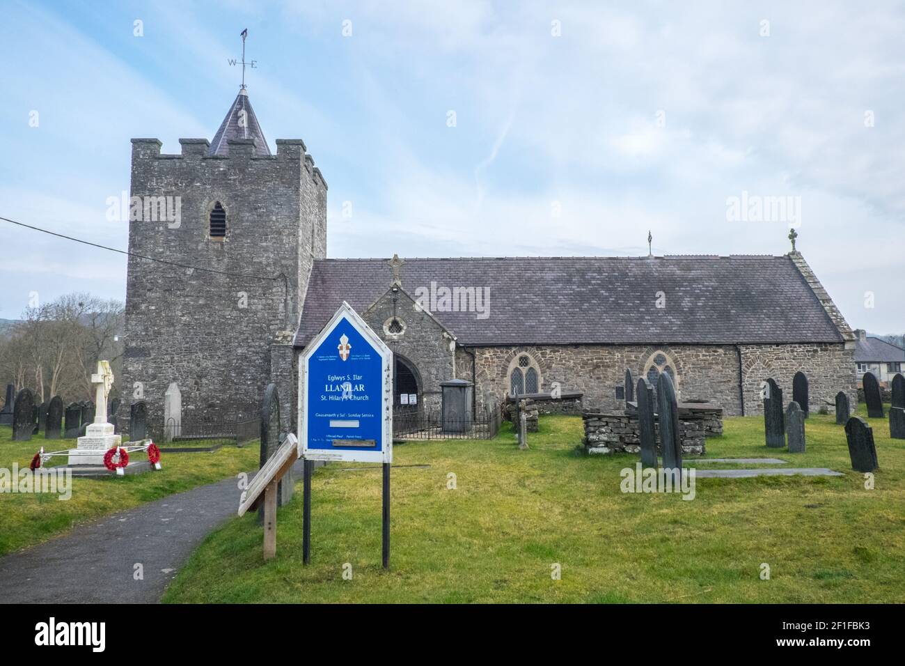
Die St. Hilary Kirche (Eglwys Sant Ilar), ein denkmalgeschütztes Gebäude, das wahrscheinlich aus dem Dorf Llanilar von 14th century.in stammt. In der Nähe ist der Ystwyth Trail, ein 21 Meilen, 34 Kilometer, Mehrzweckpfad, genutzt, von Hundewanderern, Wanderern, Spaziergängern, Radfahrern, Joggern, und Teil Pferd Reitweg, für Reiter. Die ehemalige Traillinie verbindet die studentische Küstenstadt Aberystwyth,ON, Cardigan Bay, mit Tregaron,both,in Ceredigion. Der Weg verläuft meist entlang des Flusses Ystwtyh. Foto aufgenommen zwischen Llanilar Dorf und Transgoed, ländlich, Landschaft, Landschaft, Ceredigion, Wales, Walisisch, Großbritannien, GB,
6708 x 4472 px | 56,8 x 37,9 cm | 22,4 x 14,9 inches | 300dpi
Aufnahmedatum:
8. März 2021
Weitere Informationen:
Dieses Bild kann kleinere Mängel aufweisen, da es sich um ein historisches Bild oder ein Reportagebild handel
The Ystwyth Trail is a 21-mile (34 km) multi-use rail trail linking Aberystwyth, Llanfarian, Ystrad Meurig and Tregaron in Ceredigion, Wales.[1] Cycling and walking are permitted along the entire length while horseriding is permitted on several sections only. The £1.7m Ystwyth Trail was partially completed in September 2008 and runs along part of the former redundant track bed of the Old Manchester and Milford Railway, a Great Western Railway branch line. It remains incomplete, as several sections of the former railway line were not purchased to create the trail due to extensive lobbying by local councillors of Ceredigion County Council against the trail, as existing landowners and farmers objected to the construction of the trail. Diversions of the trail have now been carried out onto narrow sections of existing public roads to link these missing sections, but this has created a non continuous trail with intermediate road sections on narrow roads which have considerable safety issues due to their narrowness, many bends and no traffic speed limits. Due to these objections and lobbying, it is unlikely that this trail will be developed or completed any further. Anglican parish church, rubble stone with slate roofs, nave and chancel in one, W tower, C19 S porch and N vestry. Tower is broad with battered base, W recessed pointed door with ashlar voussoirs, renewed in 1874, and 1874 2-light pointed window above with quatrefoil in head, and small single light above. NE stair projection with 2 small loop lights. Bell-openings are of 1874, single pointed cusped lights with louvres. Battlement without corbel course below, with C19 rock-faced stone coping. Recessed slate octagonal short spire with weathercock. Buttress at SE at joint with nave. Nave windows of 1874 are The Ystwyth Trail links with other routes via Lampeter and Devil's Bridge creating a link with both the Lôn Cambria and Lôn Teifi long distance cycling routes (Sustrans national network routes 81 and 82).
Ausschließlich für die redaktionelle Nutzung verfügbar. Wenden Sie sich bitte an uns bei kommerzieller
Eine kommerzielle Nutzung umfasst Werbung, Marketing, Verkaufsförderung, Verpackung, Advertorials und Konsumgüter oder Merchandising Produkte.
oder privater Nutzung
Private Ausdrucke, Karten und Geschenke oder Referenz für Künstler. Nur für nicht kommerzielle Nutzung, nicht für den Wiederverkauf bestimmt.